
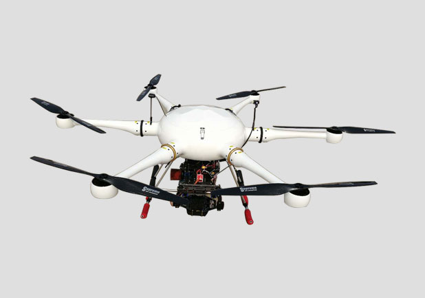
Hydroelectric Hybrid Six-Axis UAV Topographic Survey System
UAV parameters
Axle Base: > 16000 cm
Maximum take-off weight: 19.5kg
Maximum Load Weight: 5kg
Self-weight: 12.8kg
Maximum rising speed: 6m/s
Maximum descent rate: 4m/s
Body structure: plug-in structure
Power system: oil-electric hybrid system, no need to replace batteries, low cost
Arm structure: fast plug-in, no tool disassembly
Landing gear: automatic take-off and landing
Load Replacement: Manual Disassembly Structure
Maximum flight speed: 12m/s
Load: 5kg Duration: 100mins
Maximum communication radius: 15km (no interference, no occlusion)
Wind Resistance Level: Level 5
Rainproof grade: light rain
Suggested altitude: 2000 m
Power supply system: hybrid power generation, normal flight time 2 hours (load 3 kg)
UAV Safety Indicators
Support Low Voltage Protection Function Autonomous Return
Obstacle Route Avoidance
Ground Station Software
Ground station software is a new generation of navigation and flight control system with high integration and reliability for industry-class UAV. It can support VTOL hybrid wing, fixed wing, helicopter, multi-wing and other types of aircraft. Integrated Inertial Measurement Unit (IMU) and data link with communication distance up to 60 km* are the best avionics solutions for small electric UAV. It has excellent reliability by using MS sensor, all-metal shielding case and J30 aeronautical connector compensated by - 15 ~85 ~C. Using double-layer extended Erman filter, improved L1 guidance law and ADRC controller as the core algorithm of navigation flight control, it has very high control precision and cross-platform ground station software, which can run under Windows, Linux, MacOS, Unix, FreeBSD, iOS, droid and other operating systems, and meets the extremely high reliability requirements of the operating system. Application occasion. The ZDLink communication protocol with proprietary intellectual property rights can provide SDK development kit for on-board and cross-platform PC terminals for industry customers. It is convenient for industry users to integrate into their own systems. It can even keep the original operation unchanged and seamlessly replace navigation flight control system.
2. Characteristics and Application
Integrated the inertial measurement unit, triaxial magnetometer, barometric altimeter, GNSS module, and temperature compensation of - 15 - 85 degrees Celsius for the inertial measurement unit and triaxial magnetometer.
Built-in 900MHz data link, communication distance up to 60km*.
Dual integrated navigation system. The information of inertial measurement unit, three-axis magnetometer, barometric altimeter and GNSS module is fused by using double-layer 17-order extended Kalman filter, which can automatically switch between GNSS/INS and AHRS/DR navigation mode according to the presence of satellite signals.
Excellent internal shock absorption structure effectively reduces the impact of vibration on inertial measurement unit.
The improved L1 guidance law and ADRC controller are used to improve the control accuracy and robustness of the system.
Support automatic take-off, automatic return, automatic landing, route mode, intelligent protection and other functions.
The built-in global geomagnetic model and polar flight-tested magnetic compass calibration algorithm enable LEO to complete magnetic compass calibration with one click and take off immediately after satellite positioning.
Powerful remote technology services, no matter when and where users can request AheadX official remote technology support through the Internet at any time. Ten mission routes, a single mission routes up to 200 points, while supporting the automatic route jump function. It has the functions of fixed-point, equidistant and isochronal shutter photography, and records POS data of aerial photography points at the same time. Arbitrary installation mode. LEO has the function of installation angle correction and arm compensation, and can be installed on the aircraft at any installation angle and position.
Simulated training function. LEO can be used with AheadX semi-physical simulation system to facilitate daily simulation training for UAV pilots.
Built-in black box data recording function, can cycle about 60 minutes of flight data. Support to connect external data recorder, record up to 2000 hours of flight data. Online upgrade function. Users can quickly access the latest version of firmware and ground station software through the Internet. Optionally close the built-in data link and expand the use of external data links. As a new unmanned aerial vehicle, multi-rotor has high safety, simple operation, strong maneuverability, easy to carry, no takeoff and landing.
Limited and other advantages, can adapt to a variety of working occasions.
LEO-MR flight control system is widely used in aerial photography and autonomous operation of multi-rotor UAV in complex environment.
- prev:none;
- next:3-D Laser Acquisition System